Originally, the acquisition of high quality Digital Elevation Models (DEM) was dominated by the use of airborne LiDAR. Meanwhile, automatic image based collection revived as a suitable alternative. This development was triggered by the increasing quality of digital airborne cameras as well as innovations in matching algorithms. Airborne imagery of good dynamic and signal-to-noise-ratio as available from digital aerial cameras is highly beneficial for automatic image matching. This is especially true for surfaces with relatively little surface texture. Consequently, the quality and accuracy of image based point transfer as basic observation for 3D surface reconstruction ameliorated considerably.
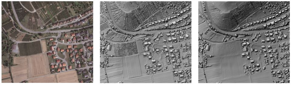
As shown for a small subset of the ifp test site in Vaihingen/Enz (left), differences between DSM from image matching (middle) and airborne LiDAR (right) are rather small and mainly correspond to vegetated areas. Due to the time gap of four weeks between the image collection and the LiDAR flight the differences are mainly a result of plant growth.
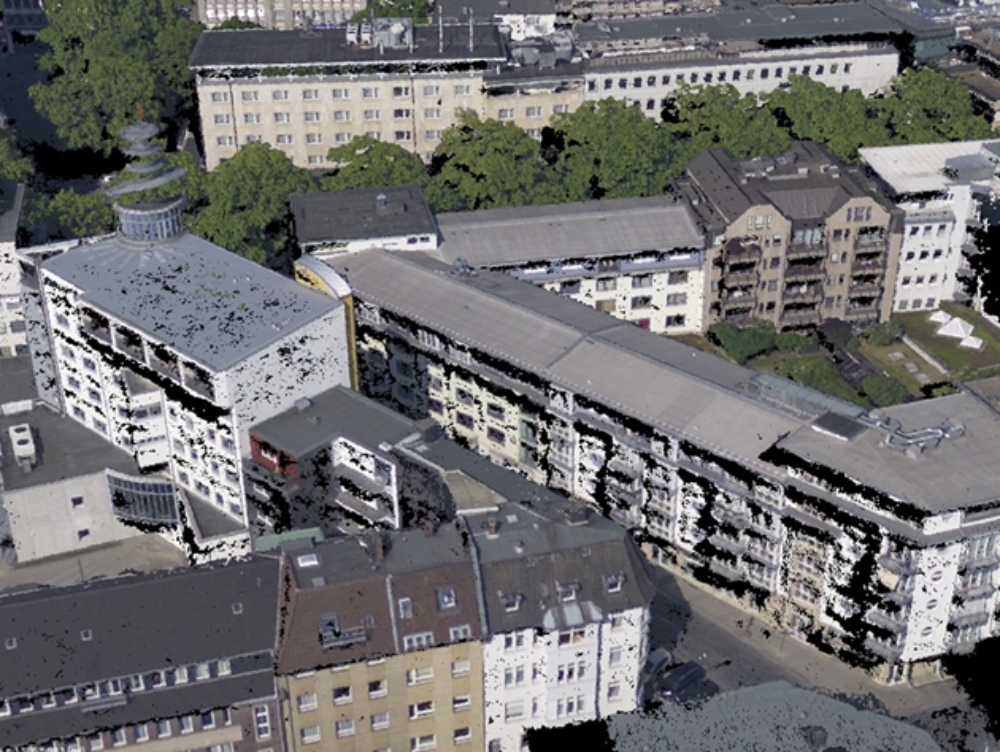
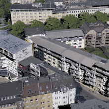
One example for dense image alignment is the Semi-Global Matching (SGM) stereo method, which is also used within our software development. Since it provides depth estimations for each image pixel a computation of dense 3D point clouds and DEM at surface resolution similar to the ground sampling distance of the available imagery is feasible. As also verified by a current Benchmark on High Density Aerial Image Matching this method was shown to work reliably on standard nadir image blocks as well as for oblique configurations which cause the matching to be more challenging due to larger variations of viewing angles and image scale. In this way results from nadir imagery can be further enhanced by complete house facades and 3D structures as balconies and treetops.
References
Haala, N. & Cavegn, S. [2016]
High Density Aerial Image Matching: State-of-the-Art and Future Prospects. Int. Arch. Photogramm. Remote Sens. Spatial Inf. Sci., XLI-B4, pp. 625-630.
DOI: 10.5194/isprs-archives-XLI-B4-625-2016
Haala, N. [2014]
Dense Image Matching Final Report, EuroSDR Official Publication N°64, pp .115-145
Cavegn, S., Haala, N., Nebiker, S., Rothermel, M. & Tutzauer, P. [2014]
Benchmarking high density image matching for oblique airborne imagery. The International Archives of the Photogrammetry, Remote Sensing and Spatial Information Sciences, Volume XL-3, 2014, ISPRS Technical Commission III Symposium, 5-7 September 2014, Zurich, Switzerland. pp. 45-52.
DOI: http://dx.doi.org/10.5194/isprsarchives-XL-3-45-2014
Rothermel, M., Wenzel, K., Fritsch, D. & Haala, N. [2012]
SURE: PhotogrammetricSurface Reconstruction from Imagery. Proceedings LCD Workshop, Berlin, December 2012.
Wenzel, K., Rothermel, M., Haala, N. & Fritsch, D. [2013]
SURE – The ifp Software for Dense Image Matching. Photogrammetric Week '13, Ed. D. Fritsch, Wichmann, Berlin/Offenbach, pp. 59-70.
Haala, N. & Rothermel, M. [2012]
Dense Multi-Stereo Matching for High Quality Digital Elevation Models in PFG Photogrammetrie, Fernerkundung, Geoinformation. Jahrgang 2012 Heft 4 (2012), p. 331-343.
http://www.schweizerbart.de/papers/pfg/detail/2012/78382/Dense_Multi_Stereo_Matching_for_High_Quality_Digit
Haala, N. [2011]
Multiray Photogrammetry and Dense Image Matching, Photogrammetric Week 2011, Wichmann Verlag, Berlin/Offenbach, pp. 185-195.
Rothermel, M., Haala, N. [2011]
Potential of Dense Matching for the Generation of High Quality Digital Elevation Models ISPRS Hannover Workshop 2011: High-Resolution Earth Imaging for Geospatial Information, IASPRS, Volume XXXVIII-4/W19, 2011.
http://dx.doi.org/10.5194/isprsarchives-XXXVIII-4-W19-271-2011
Haala, N. [2009]
Comeback of Digital Image Matching, Photogrammetric Week 2009, Wichmann Verlag, Heidelberg, pp. 289-301.
Cramer, M. & Haala, N. [2010]
DGPF Project: Evaluation of digital Photogrammetric Aerial-based Imaging Systems – Overview and Results from the Pilot Center Photogrammetric Engineering & Remote Sensing Vol. 76, No. 9, September 2010, pp. 1019-1029
http://digital.ipcprintservices.com/publication/?i=45474&p=&l=&m=&ver=&pp
Haala, N., Hastedt, H., Wolff, K., Ressl, C. & Baltrusch, S. [2010]
Digital Photogrammetric Camera Evaluation - Generation of Digital Elevation Models Photogrammetrie - Fernerkundung - Geoinformation (PFG). Heft 2 pp. 99-115.

Norbert Haala
apl. Prof. Dr.-Ing.Deputy Director