Robin Höltzcke
Remote Sensing-based Analysis of Absorbed Photosynthetic Active Radiation (APAR) on Land under Adaptive Multi-paddock Grazing
Duration: 6 months
Completition: May 2021
Supervisor: M.Sc. Philipp Schneider
Examiner: Prof. Dr.-Ing. Uwe Sörgel
Motivation and Aims
Grasslands cover about 40% of the global landmass, excluding Antarctica and Greenland. These play a crucial role when it comes to ecosystem services, such as climate regulation, atmospheric gas exchange, clean water, food, and fibre. Since herbivore herds have coevolved over millennia with grasslands, the continuous reduction of herd numbers, as well as their domestication, has resulted in large scale land degradation among all continents. With a steadily rising population, which is estimated to exceed the 10 billion mark by the year 2100, the demand for basic necessities such as access to nutritious food and clean water will further increase. To counteract the environmentally and socially adverse unintended consequences of the livestock management practices to date, a contextual decision-making framework (Holistic Management) has been developed. However, nowadays no scientific consensus on the ecological benefits of the above-mentioned framework has been found.
In this light, remote sensing techniques are employed over compared areas of study to assess the absorbed photosynthetic active radiation (APAR) of green vegetation. The compared study areas consist of land under adaptive multi-paddock grazing (AMPG) in contrast to neighbouring land of unknown management (UM). Covering a broad range of latitudes, the nine different study sites represent most of the world’s grasslands under climatic diverse conditions. The APAR data, retrieved from high-resolution optical satellite imagery (10m/pix) provided by the Sentinel-2 mission, are to serve the land managers to monitor the energy flow of the sites and enhance their land management.
Methods
The assessment of the APAR between 2017 and 2021 at the study sites was carried through the application of the Monteith Model, which explains the transformation of energy emitted by the sun into the generated biomass of vegetation. However, the efficiency of vegetation to make use of the absorbed radiation (APAR) is attributed to high variations due to biotic and abiotic factors. Therefore, the investigation was limited to the amount of radiation absorbed by green vegetation in order to mitigate uncertainty of the results. The APAR itself is determined through the product of the amount of photosynthetic active radiation (PAR) and the fraction of the absorbed PAR (fAPAR). As the Sentinel-2 mission does not provide direct fAPAR data, the NDVI was employed to estimate the fAPAR. A correlation between ground measured fAPAR and Sentinel-2 NDVI at 10m/pixel served a common approximation of the absorption of PAR of the present grasslands at the study sites. As in optical satellite imagery snow and cloud cover disable the measurement of the reflection of vegetation, the associated pixels were masked. The comparison between the areas with AMPG and UM was performed with a weighted average of the individual APAR time series of each paddock. This allowed to further reduce the loss of data as not every paddock was covered in the presence of clouds or snow.
Results and Discussion
The APAR analysis of land with AMPG and UM revealed that averagely 78% of the study sites with AMPG absorbed more radiation than their respective comparisons. The analysis of the inter-annual APAR variations showed that under favourable climatic conditions the APAR increased more over time on land with AMPG in contrast to land of UM.
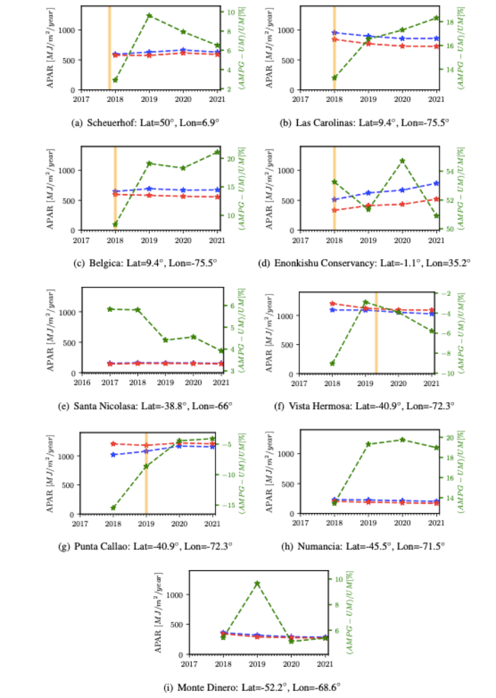
What is more, the APAR decreased in a weaker manner on land with AMPG compared to the land of UM in years of adverse climatic conditions. This dual effect may be explained by the fact that the land managers at the AMPG sites aim to improve, through planned grazing, the ecosystem processes (mineral cycle, water cycle, energy flow, community dynamics). As all these processes are highly interlinked, the study assumes that a higher APAR implies improved ecosystem functioning. However, the APAR data contains only a small fraction of information of all the biological processes which depend upon the absorption radiation and its conversion into biomass. Therefore, the application of such data for management purposes has to be further studied in order to better understand its meaning and to avoid unintended consequences arising from data misinterpretation. As the land managers at the AMPG sites already employ ecosystem monitoring procedures, this high-resolution data has the potential of being integrated into it for improved decision-making. Further analysis of the APAR data could couple the number of animals and the grazing period in order to estimate how a change of APAR correlates with the grazed forage.
Ansprechpartner

Uwe Sörgel
Prof. Dr.-Ing.Institutsleiter, Fachstudienberater