Sixie Dai
Shading of Elevation Model from Laser Scan Data
Duration of the Thesis: 6 months
Completion: October 2019
Supervisor: Prof. Dr.-Ing. Norbert Haala, Dr. Richard Steffen, M.Sc. Martin Graner (PointCab)
Examiner: Prof. Dr.-Ing. Norbert Haala
Introduction
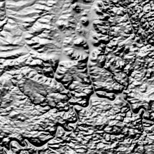
The elevation model from laser scan data cannot represent the spatial relationships of the terrain features, so the shading of the elevation model should be generated to represent the spatial relationships. Shaded relief is a method for representing topography on maps in a natural, aesthetic, and intuitive manner. Generating analytical relief shading requires complete dense elevation data (Räber et al., 2009). However, generally, the elevation model from laser scan data has some holes. To generate relief shading from this data, holes are firstly filled by a proper method combined with image inpainting technique. The original standard relief shading can be produced quickly, but the terrain features are not visually well emphasized as they are in manual relief shading. Current approaches improve standard analytical relief shading by emphasizing on terrain features and adjusting illumination direction. In this thesis, two previous approaches to improve standard relief shading are introduced and compared. Next, a new method is proposed which can simulate the shading effect of manual relief shading by locally adjusting illumination direction based on the aspect of ridges.
Methodology
The laser scan data are firstly preprocessed with an image inpainting algorithm based on coherence transport to fill in the holes. Next, the new relief shading, in which the illumination direction is locally adjusted based on the mean aspect in each grid, can be generated by the proposed method. The whole procedure to generate the relief shading is shown in Figure 1.
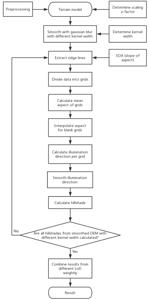
The digital elevation data are smoothed by Gaussian filter with different kernel width to generate relief shading from different levels of detail and to remove intricate details in small-scale maps. Next, ridges are detected by the slope of aspect (SOA). The smoothed elevation data are divided into grids. The illumination direction in each grid is determined by the mean aspect of the extracted ridges in the grid and is smoothed by Gaussian blur. The final results of the proposed method are combined from relief shading from various levels of details by weights.
Results
The final results of three input datasets are generated from the combination of two adjusted relief shading from different blur levels, in which the illumination direction is smoothed by Gaussian filter. For the Bavaria dataset tile No.19 which is an area with ridges, valleys, and plain area. The result of the proposed method is much better than the standard relief shading. The ridge lines are emphasized, and the terrain structure is clear, while the ridge area in the left column of Figure 2 remains in dark tone and the terrain structure is unclear. The mean value and the image entropy increased by applying the proposed method, which also proves the subjective evaluation from human eyes.
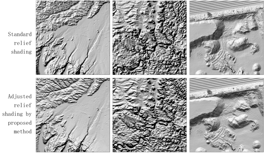
However, the improvements of the other two tiles are not as obvious as it is in the Bavaria dataset tile No.19. Because in these tiles, the area is either with complicated terrain structure or with little clear ridgelines. The improvements can be seen in the details: In Drone dataset tile No.12, the tracks of the tractors are emphasized by the proposed method.
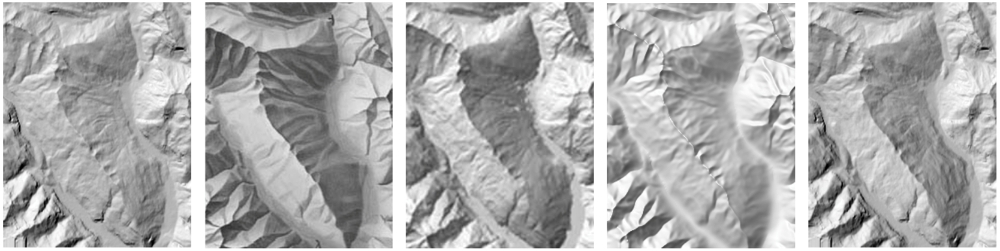
Lastly, the result of the proposed method is compared with the results achieved by other methods and the standard relief shading, and the manual relief shading. Figure 3 shows the relief shading of peak Pizzo Erra from the Ticino section of Graubuenden, which is particular because the ridgeline lies right parallel to the global illumination direction of the standard analytical relief shading. The ridgeline in Leonowicz’s result cannot be well emphasized because the illumination direction is not locally adjusted. And the end of the ridgeline at the bottom of the image in Marston’s result is unclear because of the diffusion curve algorithm and ridgeline simplification. Unlike the results of the previous approaches, the result of our method can good simulate the shading effect of the manual relief shading, and the total ridgeline is very clear. Moreover, our method is much simpler and more effective than previous approaches.
Conclusion
The proposed method is very effective because it has a better shading effect but the simpler principle and shorter computing time than the previous approaches. By locally adjusting the illumination direction in each grid, it can well simulate the shading effect of the manual relief shading. The ridgelines can be significantly emphasized, and the users can more easily perceive the terrain structures. It can effectively increase the information amount of the images. However, this method is more suitable for areas with clear ridgelines. For the areas with complicated terrain structure or with little clear ridgelines, the improvement of this method is not obvious.
References
Leonowicz, A. M., Jenny, B., and Hurni, L. (2010). Terrain sculptor: generalizing terrain models for relief shading. Cartographic Perspectives, (67):51–60.
Marston, B. E. and Jenny, B. (2015). Improving the representation of major landforms in analytical relief shading. International Journal of Geographical Information Science, 29(7):1144–1165.
Räber, S., Jenny, B., and Hurni, L. (2009). Swiss style relief shading methodology: Knowl- edge base for further development and application in digital cartography. Institute of Cartography, pages 1–9.
Ansprechpartner

Norbert Haala
apl. Prof. Dr.-Ing.Stellvertretender Institutsleiter