Muhammad Ali Iftikhar
Spatially Aware Conversational Agent
Duration of the Thesis: 6 months
Completion: October 2017
Supervisor: Dr.-Ing. Volker Walter
Examiner: Prof. Dr.-Ing. Uwe Sörgel
Introduction
Due to the exponential growth of technology in recent times, there are sudden paradigm shifts in how humans use machines to interact with each other. In the last quarter of 2015, the number of people using messenger apps has majorly outnumbered those of social media apps. This shift in the trend has stimulated major tech giants to invest heavily in artificial intelligence for Textual User Interface (TUI) in the form of bots.
Humans tend to understand conversational set of instructions quiet easily. Research in Machine learning and Artificial Intelligence (AI) has made bots specialized in giving human like responses to a given set of inputs. Our proposed idea is to build a bot with the capability to give spatially aware outputs. The bot will be trained on large amounts of location data. Every input will be processed by a machine learning and NLP unit to extract the right parameters and generate a technically accurate human like response.
A closer understanding of the topic reveals that unlike the current automated location services available, the bot aims at giving user an answer which takes into account present state of internal and external factors. The bot can influence which route the user should take or what the time of departure should be or even give an array of suggestions to pick from, based on user preferences. If a high rate of meaningful responses is achieved through this, we are looking at a granular automation of location based services in the future..
Methodology
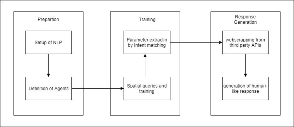
Keeping the goal of the research in sight, the methodology has been implemented to animate each step in prototyping a spatially aware chatbot.
The workflow begins with setting up the NLP processor which in our case is Api.ai. The processor is then trained with spatial queries to correspond to our selected spatial domains for example traffic. Depending on the quantity and quality of the training dataset, the accuracy of parameters extraction can be improved.
Once the accuracy of parameter extraction is reasonable, the model is connected to a web scraping server. The role of web scraper is to connect to different services which provide data about our parameters. After receiving the scraped data, the last step is to generate human-like responses with appropriate tone and variations.
The divisions in workflow clearly highlight the journey of an input to the generation of a potentially human-like response. The methodology can be broadly divided into three subsequent steps,
- Preparation
- Training
- Response Generation
The figure summarizes the entire methodology of the prototype of the spatially aware chatbot
Conclusion
In terms of practicality, a spatially aware chatbot has a great potential for making its space in everyday human life. However, the complexity of AI algorithms is augmented with the introduction of spatial data which is a different language altogether. Hence, it is important to discuss where the current research and the developed prototype stands in terms of important aspects such as usability and how the limitations can be minimized.
In terms of usability, a spatially aware chatbots is an idea that instantly strikes. Everyday life of an average human being is riddled with spatial queries in implicit and explicit form. From holidaying in an unknown location to selecting right the hiking shoes, a chatbot specializing is spatial data would be game changer. In general, the prototype developed in this research allowed a layman user to ask a spatial query with extreme ease. Furthermore, it was also able to extract the necessary parameters efficiently in nearly all simple queries. For more complex queries, with the correct intent training, it was able to understand the context of a continuous conversation where a spatial agent was the main context.
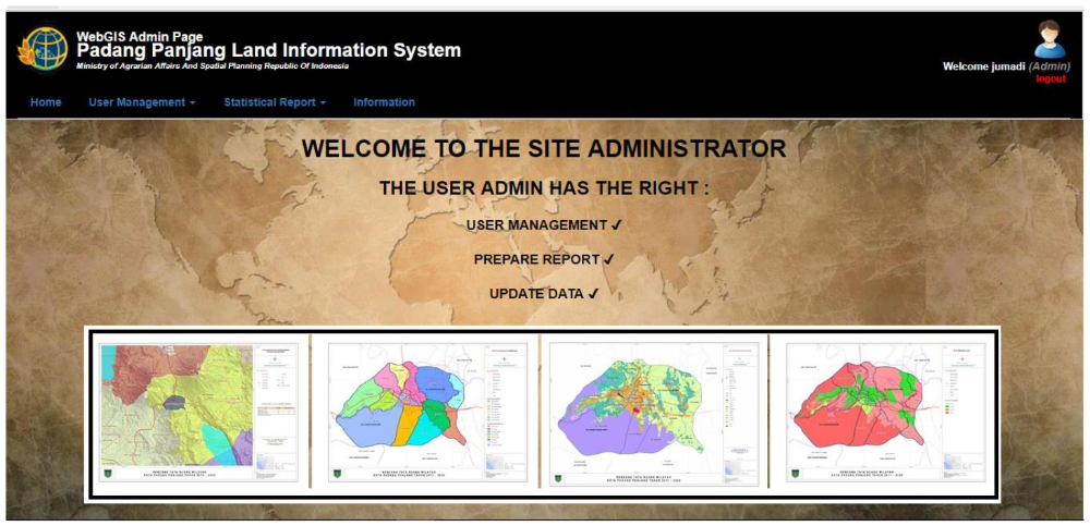
G. Administration Part
In Administration part, there are some facilities which are provided for the administrator to check the list of the user, create new user, and geo statistical data report. The administration part can be seen in figure 11 and 12 below.
Conclusions
- There is a growing need of WebGIS cadastral/land information as a tool for legal, administrative, economic and decision making.
- QGIS, GeoServer, PostgreSQL/PostGIS, LeafletJS work optimal for developing WebGIS application
- Leaflet provides a lot of Plugins (GIS power)
- Interactive map application is the key of Cadastral web application
- Spatial analysis tools is a power of WebGIS
- Security login is needed since the data is sensitive
Ansprechpartner

Volker Walter
Dr.-Ing.Gruppenleiter Geoinformatik