
Sijian WANG
Comparison of Different Transformations of Direct Georeferencing in National Coordinates
Duration of the Thesis: 6 months
Completion: December 2016
Supervisor: Dr.-Ing. Michael Cramer
Examiner: Prof. Dr.-Ing. Norbert Haala
Introduction
Nowadays the application of direct georeferencing (DG) has become an inherent part of modern airborne mapping instrumentation due to its various advantages. Exterior orientation (EO) parameters are able to be observed independently by using integrated global navigation satellite system (GNSS) and inertial navigation systems (INS). Hence, exterior orientation parameters are related to the reference frame of GPS, which are with respect to the instantaneous tangent to the WGS84 ellipsoid. Furthermore, the georeferencing process is based on Cartesian coordinates. However, in most cases the photogrammetric products are often required in national ellipsoid and mapped by map projections which is not Cartesian due to the earth curvature and length distortion. Therefore, several transformations are necessary to obtain the desired products in national coordinates. In this thesis project, several different transformation methods in the literature are proposed and compared by both simulated and real data.
Transformation methods for direct georeferencing
There are primarily two transformation approaches from the local tangent frame of the GNSS/inertial system to the map projection frame for DG in previously published papers. The first method is to transform the final restitutions which have performed in one Cartesian reference system, e.g., one tangential plane at some central position of the area of interest. After determining the point cloud of the restitution, a series of transformations will be conducted to each point in the reconstruction. It is the rigorously correct and theoretically the best way. Nevertheless, this method also has some practical drawbacks such as enormous computational efforts. The second one is to transform the original EO parametersobtained by GNSS/inertial system into national coordinate system and then attain the final results by the transformed EO parameters as well as additional necessary corrections. More specifically, this paper presents two detailed method for the transformation of EO parameters. One is Legat method and the other one is Coordinate Transformation method. Moreover, this method needs corresponding corrections, which is comprised of standard earth curvature correction and additional height correction.
Validation of transformation methods
In order to validate the transformation methods, one simulation based on Legat method is improved and augmented to demonstrate the distortions numerically. Furthermore, a real data project conducted by AVT company is also implemented.
Simulations
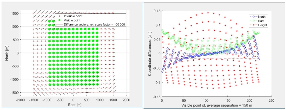
The simulator was designed in the Matlab software with the help of Graphical User Interface (GUI). This simulator generated an artificial terrain with a regular quadratic grid of 21×21 points with suitable point separation, spatial orientation and placement and defined the EOs for one stereo pair images. Afterwards the coordinate differences between the aforementioned two primary different transformations are calculated and visualized. A few corresponding comparisons are demonstrated in details. The following figure shows the visualization in one specific situation, the coordinate differences between the rigorous transformation and Legat method.
Empirical Data Project
For purpose of validating the direct georeferencing consequences and assessing the accuracy of the real-world conditions obtained via the transformation of EOs in national frame, one set of empirical investigations were also utilized. This is a test flight flown over a mountainous city, Sölden, Austria, which was implemented by 3 AVT company. Particularly, the results of real data project is compared with the simulated data.
Conclusions
This paper has mainly presented series of different transformation methods for direct georeferencing in national coordinates based on the literature methods. All of the investigations are intended to enable the scene restitution directly in the national coordinates by only transforming the EO parameters of direct georeferencing. The transformation to the final restitution is the most rigorous correct way, which could be considered as the true value. Nevertheless, in order to cope with more directly and efficiently, transforming only the exterior orientation parameters is preferable. Along with the corresponding corrections, the transformations of EOs with two specific methods are able to reach an acceptable consequence.
References
[1] Schenk T. Introduction to photogrammetry[J]. The Ohio State University, Columbus, 2005.
[2] Ressl C. The impact of conformal map projections on direct georeferencing[J]. International Archives of Photogrammetry Remote Sensing and Spatial Information Sciences, 2002, 34(3/A): 283-288.
[3] Hofmann-Wellenhof B, Lichtenegger H, Collins J. Global positioning system: theory and practice[M]. Springer Science & Business Media, 2012.
[4] Zhao H, Zhang B, Wu C, et al. Development of a Coordinate Transformation method for direct georeferencing in map projection frames[J]. ISPRS journal of photogrammetry and remote sensing, 2013, 77: 94-103.
[5] Legat K. Approximate direct georeferencing in national coordinates[J]. ISPRS Journal of Photogrammetry and Remote Sensing, 2006, 60(4): 239-255.
[6] Cramer M, Stallmann D, Haala N. Direct georeferencing using GPS/inertial exterior orientations for photogrammetric applications[J]. International Archives of Photogrammetry and Remote Sensing, 2000, 33(B3/1; PART 3): 198-205.
[7] ReferenceManual_ApplicationsMaster_(English)_61
Ansprechpartner

Norbert Haala
apl. Prof. Dr.-Ing.Stellvertretender Institutsleiter