Bo Feng
Digital Preservation of Calw Altburgerstrasse by Means of Automated HDS and Photogrammetric Texture Mapping
Duration of the Thesis: 6 months
Completion: March 2016
Supervisor & Examiner: Prof. Dr. –Ing. Dieter Fritsch
Supervisor: Dr.-Ing. José Balsa-Barreiro
Introduction
Digital heritage is the use of digital media for preserving the cultural heritage. The Charter on the Preservation of Digital Heritage of UNESCO defines digital heritage as embracing "cultural, educational, scientific and administrative resources, as well as technical, legal, medical and other kinds of information created digitally, or converted into digital form from existing analogue resources".
The integration of cultural heritage preservation and digital technology is an important international trend in the 21st century. The digital technology can record and preserve detailed documents and information of heritage completely, but also brings the value-added features in an effective way. In the current study, 3D laser scanning is used to perform the digitalized archives for the interior and exterior body work of the building which contains integration of 3D scanner technology, mobile scanning collaboration and multi-system reverse modeling and integration technology. 3D models are built by combining with multimedia presentations and reversed modeling in real scale to perform the simulation of virtual reality (VR).
With the upgrade of the technology and value-added in digitalization, the cultural asset value can be experienced through 3D virtual reality which makes the information presentation from the traditional reading in the past toward user operation with sensory experience and keep exploring the possibilities and development of cultural asset preservation by using digital technology makes the presentation and learning of cultural asset information toward diversification.
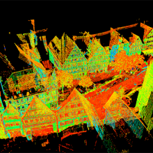
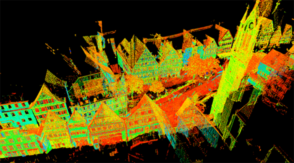
In this study photogrammetry and laser scanning techniques are used for digital documentation of preserved areas in historical urban environment. Leica Scan Station P20 is used for digital laser scanning. Leica Cyclone, TrimbleSketchUp, Cloud Compare, SURE, among other software programs are used for the different phases of this Master Thesis.
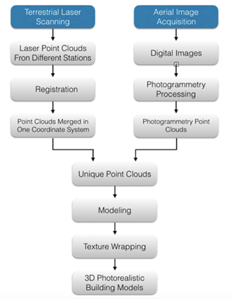
2. General Working Flow:
3. Terrestrial LiDAR
If the lens is tilted the geometry inside the camera is changing. In the Fig.2 is shown the geometry of the normal case camera and the camera with the tilted lens.
4. Photogrammetry
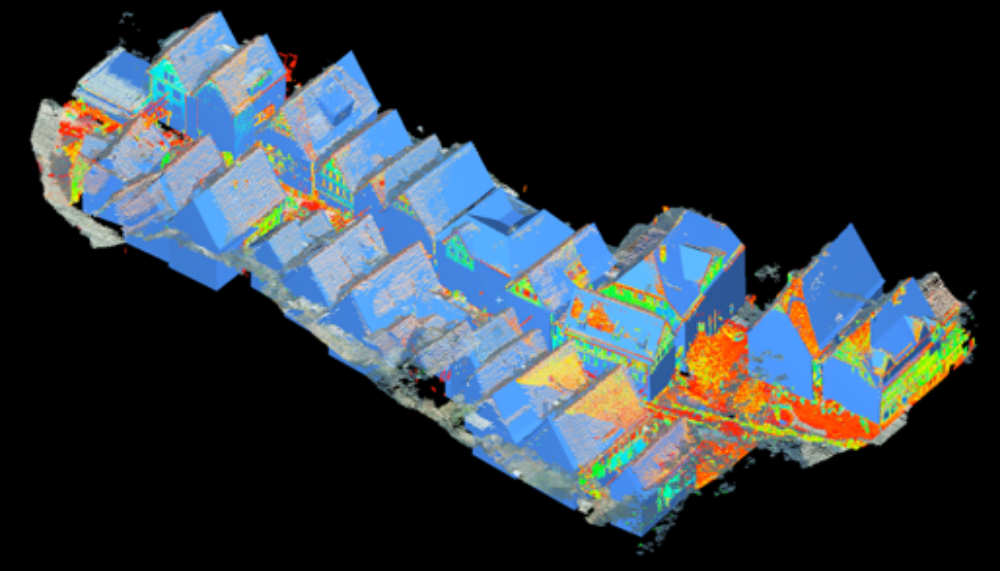
Some areas of the urban landscapes cannot completely scanned by TLS positioned in fixed locations because the limited perspective and other drawbacks. Thus, only the building façades can be scanned, but not the complete roof landscapes. For this reason, other techniques and/or technologies are required such as airborne photogrammetry.
Photogrammetry can be classified depending on different ways but one standard method is to split the field based on camera location during image capturing. Thus, it is common to distinguish between aerial, and close-range photogrammetry.
In aerial photogrammetry the camera is mounted in an aircraft and is usually pointed vertically towards the ground. Multiple overlapping photos of the ground are collected as the aircraft flies along a flight path. These photos are processed in a stereo-plotter, which is an instrument that lets to the operator visualize two photos at once by using a stereo view. These photos are also used in automated processing for generation of Digital Elevation Models(DEM).
In close-range photogrammetry (henceforth CRP) the camera is close to the subject and is typically hand-held or on a tripod (but can be on a vehicle too). Usually this type of photogrammetry is non-topographic - that is, the output is not topographic products like terrain models or topographic maps, but instead drawings, 3D models, measurements and point clouds. Often cameras are used to model and measure buildings, engineering structures, forensic and accident scenes, mines, earth-works, stock-piles, archaeological artifacts, film sets, etc. This type of photogrammetry is also sometimes called Image-Based Modeling.

5. 3D Modeling
In computer graphics, 3D modeling is the process of developing a mathematical representation of any 3D surface of an object by using some specialized software, which are known as modeling applications or modelers. The final product obtained is called 3D model. It can be displayed as a 2D image through a process called 3D rendering or used in a computer simulation of physical phenomena. The model can also be physically created using 3D printing devices.
3D models can be created automatically or manually. The manual modeling process of preparing geometric data for 3D computer graphics is similar to plastic arts such as sculpting.
6. Texture Preparation and Wrapping
The textures need be prepared before wrapping. The software used for texture preparation is Adobe Photoshop.
Texture mapping considers the image perspective, exposure time and occlusions in the camera field of view. The image perspective problem can be solved using the eight parameters of the projective transformation, while the occlusions are fixed manually via extraction and mapping. Corrections of perspective for texture mapping are carried out using the software Trimble Sketchup.

7. Conclusion
Photogrammetry is a good method to make up the drawbacks of HDS. Although due to the inconvenience and limitation of the Terrestrial Laser Scanning, some information can’t be got by TLS. The photogrammetry can almost make up all the missing areas. TLS is a very stable and accurate way for point cloud acquisition, whereas photogrammetry is a more flexible and convenient way compare to TLS. By combined two methods together, complete point clouds of the block and neighboring area can be delivered. But the quality of registration which combined the TLS data and photogrammetry data together is very important. By using Helmert transformation and ICP algorithm a result with a mean error of 0.08m can be got, but the quality can still be improved by using different method in further research.
Ansprechpartner
Dieter Fritsch
Prof. Dr.-Ing.Professor im Ruhestand